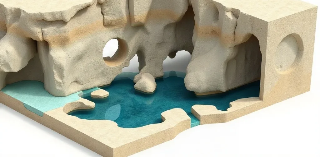
Karst speleogenesis is the process by which water dissolves soluble rock and creates caves, conduits and sinkholes such as cenotes. Studying how these passages form helps explain the shape and connection of underwater environments, while giving divers essential context for navigation, survey planning and risk.
How does water turn rock into a cave?
In limestone terrain, rainwater absorbs carbon dioxide from soil and air, becoming mildly acidic. As it moves through cracks, it dissolves calcium carbonate and gradually enlarges small openings into conduits and chambers. The resulting cave network reflects both the rock’s structure and the routes water has taken.
Groundwater level matters. When water levels change over geological time, passages may form, drain, flood again or acquire features that record earlier conditions. A cenote is a surface opening into this karst system; below it, submerged passages may extend beyond the visible pool.
What questions do cave-forming studies ask?
Researchers examine how passages relate to fractures and bedding in the rock, whether separate cave sections connect, and how water moves through the system. They may also consider how changing groundwater levels and the chemical character of water influence cave development. These questions link the visible geometry of a cave to processes that are not directly observable during a dive.
In a setting described as cenotes, the relationship between surface openings and submerged passages is especially important. A mapped opening is not necessarily a simple vertical shaft: it can lead into branching, winding or constricted routes. Understanding that three-dimensional structure is relevant to geology and to anyone planning scientific work underwater.
How do researchers investigate a submerged karst system?
Speleogenesis is studied through a combination of geological observation, cave mapping and examination of water. Divers can document passage dimensions, rock surfaces, sediment and visible features; these observations help relate the underwater route to the surrounding geology. Water measurements can help characterize conditions within a system, although any single observation describes only a particular place and time.
Mapping is also a technical task. A survey must record direction, distance and changes in passage shape, often in an environment where visibility, access and route complexity affect the work. The resulting map is both a scientific record and a practical representation of the cave’s layout, not a substitute for competent cave-diving training.
- Rock structure: cracks and bedding can influence where water travels and where passages enlarge.
- Water level: changes over time can alter which parts of a cave are flooded or exposed.
- Passage geometry: turns, branches and restrictions shape both the cave and the diver’s route.
- Water conditions: chemistry and movement help researchers interpret the system’s development.
Why does cave geology matter to divers?
Geology helps explain why a route narrows, branches or changes direction, but it does not make an unfamiliar cave predictable. A passage can continue beyond a visible opening, and a diver may lose the reference of daylight well before reaching the end of a route. In overhead environments, navigation and a continuous guideline are central safety considerations.
Scientific diving adds another demand: attention must be divided between the environment, instruments, task and team. A geological survey may require recording observations while maintaining awareness of gas supply, route and return conditions. The work therefore depends on appropriate training, planning and equipment for the specific cave and task.
Where does this research fit in diving science?
Submerged-cave research sits at the intersection of geology, hydrology and scientific diving. The cave is at once a record of water acting on rock, a habitat and a difficult environment to study. Its passages can inform questions about groundwater pathways, while careful mapping gives later researchers a spatial framework for comparing observations.
The same environment raises practical questions for dive medicine and safety. Cold, exertion, restricted access and the consequences of a problem far from an exit can affect the demands placed on a diver. These are general considerations, not a diagnosis or a personal fitness assessment; a diving-medicine physician should be consulted about individual health concerns or return-to-diving decisions.
Frequently asked questions
What does speleogenesis mean?
Is every cenote a cave entrance?
Why is cave mapping useful to scientific divers?
An original research-library explainer written by the Rubicon editors. It is not a summary of a specific publication.